


- 29 November 2025 - Coral Triangle Countries Deepen Cooperation in Priority Seascapes
- 29 November 2025 - Timor-Leste Proclamation Of Independence Day
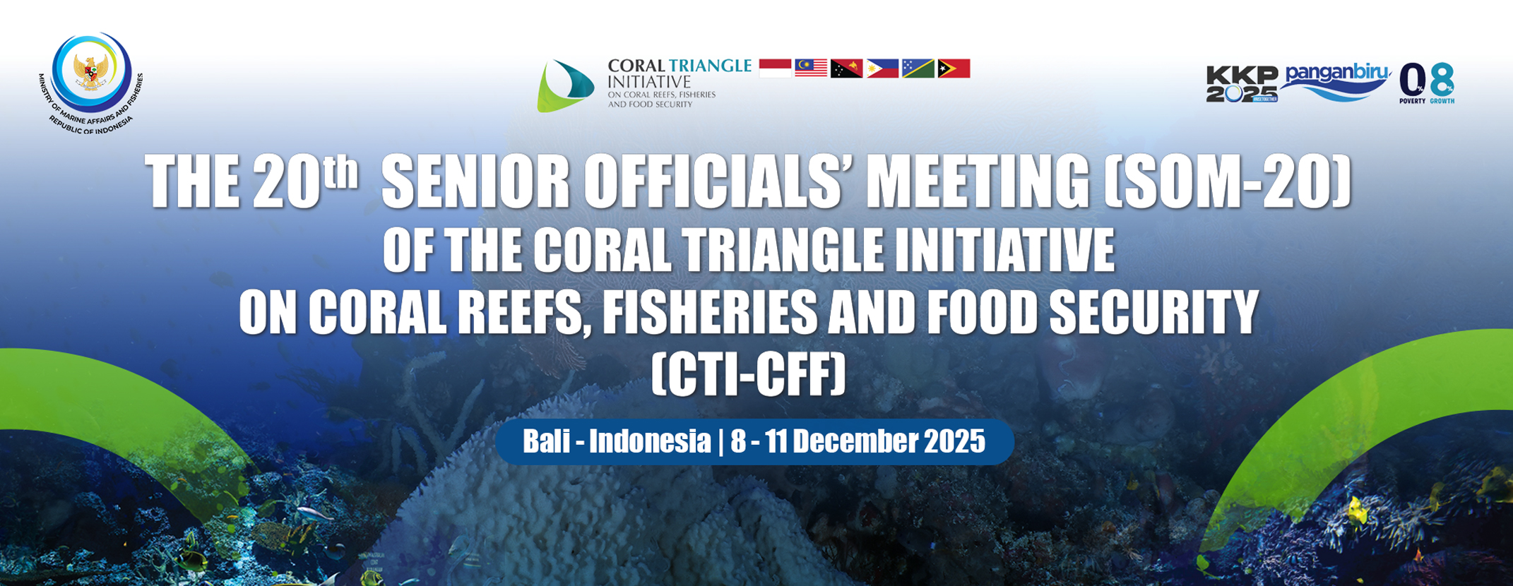
- 23 November 2025 - International Seminar on the Implementation of SDG 14 “Life Below Water” in the Coral Triangle Countries, CTI-CFF University Partnership Forum and Establishment of Lesser Sunda Seascape Science Hub
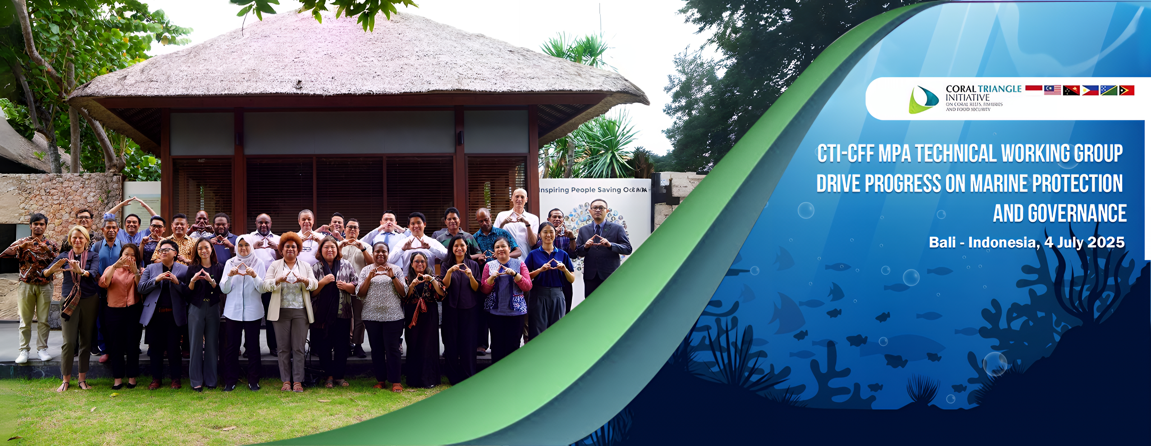
- 15 October 2025 - Strengthening Regional Partnerships Through Monitoring and Evaluation: Coral Triangle Initiative Convenes Key Working Group Meeting
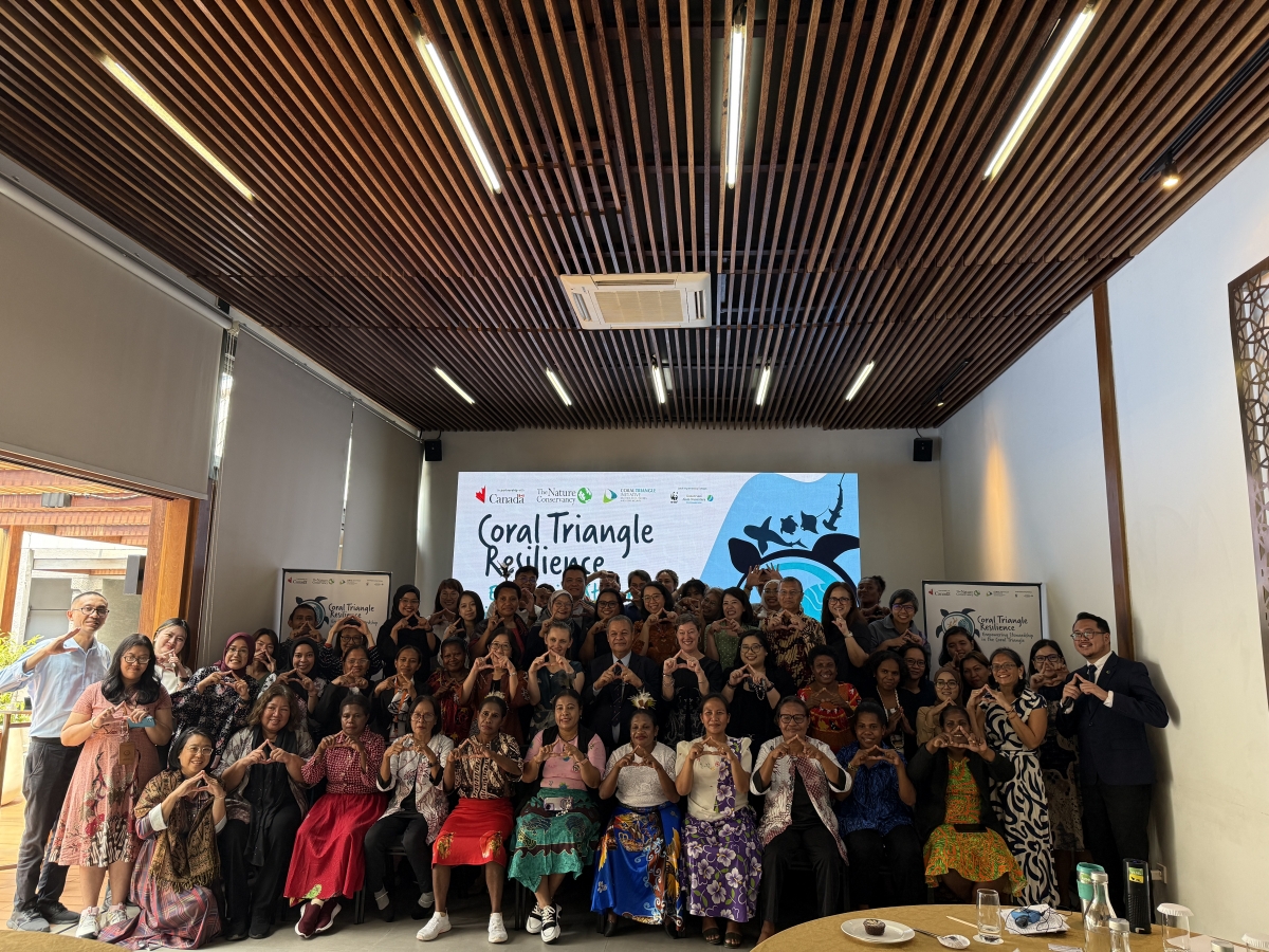
- 22 September 2025 - Solomon Islands Hosts Landmark Regional Gathering on Marine Conservation, Threatened Species, and Women’s Leadership
- 16 September 2025 - Happy 50th Independence Day, Papua New Guinea!


Browse Photo Collection


Dear Professor Pratikto,
On behalf of the Australian Government, we write to acknowledge receipt of your letter (DVP/RS/5/18/340; 22 May 2018) informing the CTI-CFF Official Development Partners of your resignation as Executive Director effective 10 June 2018.
We offer sincere thanks to you for your efforts in initiating the work of the Regional Secretariat as its inaugural Executive Director. We note your commitment to the goals of the CTI-CFF and regret that ill health has forced you to resign before fully realising the fruits of your work to build the Regional Secretariat and through it the CTI-CFF. You will understand the special place that the Regional Secretariat and indeed the position of Executive Director has for us given our support in helping to establish it and the process that led your appointment. We are sure that although you may be disappointed to leave prematurely, you have the comfort of having chosen capable people within the Regional Secretariat who will doubtless continue after your departure a productive and warm collaboration with the Australian Government.
We wish you a speedy recovery, wish you well, and thank you for your service to the CTICFF.
Yours sincerely
Paul Perrett
Assistant Secretary
Marine and International Heritage Branch
Dear Pa Widi,
am shocked and very sorry to hear of your resignation but I am even more concerned to hear of your medical condition. This is not good and I can only imagine the pain and discomfort you have been putting up with these past months. You have been very stoic in the face of this adversity but I think your decision to take care of your back in your home surroundings is very sensible and although it will be CTI Secretariat's loss, there are other more important things in life - like your good health. I am thinking of you my good friend and praying for your safe recovery—
Warmest Regards
Peter
Thank you for reaching out Pak Widi. It is good to hear from you. I’m sorry hear of the medical complications. I wish you well in your health and in next chapter of your career. I also appreciate your encouragement on The region has unparalleled marine biodiversity and is a wealth of for sustainability.
All the best, Leah
Dear Pak Widi
On behalf of your friends at The Nature Conservancy, I would like to express our sincere gratitude for all that you have done for the Coral Triangle Initiative on Coral Reefs, Fisheries and Food Security (CTI-CFF) since you took on the role of Executive Director in April 2015. We appreciate your many achievements over that period, including the establishment of the Permanent Secretariat, the ongoing engagement of the Coral Triangle member countries and development partners, as well as the formation of a large number of new and vibrant partnerships. Through your leadership of the CTI-CFF, you have made an important contribution to the people and natural environment of the unique Coral Triangle region. We are sorry to hear about your medical issues, and would like to wish you all the very best for a speedy recovery. We will look forward to working with you upon your return, in your role as Ocean Engineering Professor at Surabaya Institute of Technology.
With great respect and warmest regards
Laura Whitford
Director of Development Policy and Partnerships
The Nature Conservancy
Asia Pacific
Dear Pak Widi,
I just wanted to send a note to thank you for all your hard work as the leader and guiding force of the Regional Secretariat. I have enjoyed working with you.
I am sincerely sorry to hear about your medical problems, and I hope your treatment in Surabaya is successful. My wife has severe back problems, and I have some understanding of how it can affect your quality of life. I wish for the best outcome for you.
I also wish you the best of luck as you return to the University. I hope our paths cross again soon -- I very much enjoyed your sense of humor and kindness.
Warmest regards, Peter
Dear CTI-CFF Colleagues,
Thank you for sharing the notification regarding the resignation of the CTICFF Director, Pak Widi Pratikto. We regret to hear that Pak Widi having major back problems and we would like to take this opportunity thank him for his service to the CTI-CFF and wish him all the best for a recovery.
Kind regards, Bruce
Dear Pak Widi,
I'm so sorry to hear of your back and spine complications. Sounds terribly painful and I wish you a speedy recovery. Although you're resigning the CTI Executive Director position, I do hope to cross paths with you in another capacity in the near future. All my best to you. Thank you for being such a dedicated partner to DOI ITAP and for your lifelong commitment to protecting marine resources.
Warmest regards,
Tricia
Dear Pak Widi,
Life is too short for you to suffer, you’re certainly making the right although you will be sorely missed by the SEA and OCEANs it is more important for you to get healthy! Thank you for your whole commitment to marine biodiversity and to make a difference for the good! Don’t worry as our work will never end, therefore you will have a reason to remerge in this field. Last time we were together mentioned how excited you were to reengage with students, perhaps
this is the way forward for many of us to have the opportunity and ability to enthusiasm, knowledge and persistence in upcoming professionals.
You have a lot of wisdom and knowledge to share but first get healthy! Our are with you!
Gina
P.S. Keep in touch!
Dear Pak Widi,
I am both delighted and saddened to hear from you again.-
Both your spine issue and subsequent resignation from ED RS CTI CFF comes as a surprise. I am reminded of the time when I was sick, out of the office for eight months and then coming back to work to completely reset my priorities and management style to align better with maintaining good mental and physical health. In looking at these wonderful pictures and memories we shared in past years, I realized five years ago that while I loved my work and was so passionate about our programs, it took a bigger toll on me than I had anticipated.....hence the shift towards a more appropriate and balanced approach. Now that I have stepped back from certain aspects in my work here at NOAA, I have shifted my attention more towards delegation and mentoring the young ones, to help them rise to their full potential, and to ensure succession. While it is a different approach from what I was used to, I've come to realize and appreciate how powerful and gratifying my current practice is because of the sacrifice I made in 2013.
Pak, what you have done and will continue to accomplish and contribute to your country and to your university is a legacy that you should be very proud of, and others will continue to cherish. Life has a funny way to get your attention to tell you....'.slow down, and take better care of yourself'.......I think it's fair to say that we both have received that msg loud and clear. –
Please promise me that you will pursue the very best of medical specialist to provide you with superb expertise and the healing hands that you deserve. View it as a temporary time out, and begin to muse about how you will continue to serve, contribute, lead and mentor through your capacity at ITS Surabaya.
As you did for me then, I am sending you my prayers and very best wishes. As you begin your journey down the path of treatment and healing, my thoughts will be with you and your family.........and don't be surprised if you receive check-in msgs from me over the next few months to see how you are doing.-
God speed Pak!
Rene
Director for NOAA Intl Cooperation
Dear Pak Widi,
I was very surprised to hear the news of your resignation as Director of the CTI Secretariat but realize the urgent need for health reasons. I just want to convey my sincere thanks for all the good work you have been contributing to through the CTI Secretariat the last several years. Your total dedication and concern for the direction and success of the CTI has been obvious to all concerned and indeed you will be sorely missed in this role. I also understand that it is not an easy position to fulfill with many different expectations placed on the Director role and in this regard, I am always impressed with your fortitude to press forward with positive approaches and strategies to keep the Secretariat moving and improving.
Your main concern now is to improve the health of your back which I am sure is very painful at times and I hope that you can find a medical solution to that issue in the near future.
Lets stay in touch and if you need anything I can help with, please feel free to contact me here in Jakarta.
All the best and keep up your positive spirits! Alan
Dear Professor Widi,
Thank you for your message. I am very sorry to hear about your medical needs, and trust that you will be receiving the best possible care for a successful treatment and speedy recovery. While we will miss your collaborative spirit and warm leadership, you have nurtured an team within the CTI-CFF Regional Secretariat with whom we have confidence in and look forward to continued, productive partnership with.
On behalf of the USAID Oceans and Fisheries Partnership team, our very wishes to you on a smooth and fruitful transition back into your Professorship in Ocean Engineering at the Surabaya Institute of Technology. The Institute is truly fortunate to have your presence and leadership. We look forward to reconnecting with you once you are fully healed and have settled in at the Institute. Until then, all the best to you from all of us.
John Parks
Chief of Party
The USAID Oceans and Fisheries Partnership
Dear Pak Widi,
So sorry to hear of this news. Your dedication to the program has been unprecedented and will be surely missed. Sending you blessings for a speedy recovery.
With regards,
Gabrielle
Dear Pak,
I am so sorry to hear the news of your back issues and pray for a speedy recovery and that you receive the best and most excellent care from the surgeons. You have had a wonderful life of service and it is not over - it has been and continues to be a privilege to know you, work with you, and consider you a friend. I do hope to see you in the future - best wishes to you and yours and thank you for sharing the sad but important update regarding your health.
Michael
Terima kasih Cc-suratnya Bapak Prof Widi A. Pratikto. Saya berdoa semoga Bapak segera diberikan kesembuhan sehingga dapat beraktivitas kembali.
Banyak hal yang telah Bapak kontribusikan untuk pengelolaan terumbu karang dan laut Indonesia dan regional melului CTI. Semoga dapat diteruskan oleh ED CTI-CFF yang baru nanti.
Salam hormat
Ari Purbayanto
Atdikbud KBRI Kuala Lumpur
Kota Kinabalu, Sabah,
Dear Widi
I was very sorry to hear of your back troubles but you have certainly made right decision in focusing on getting this resolved - your good health is most important thing. I would like to say that I have very much enjoyed interactions with you over the past few years and that I am very grateful you reached out to JCU to engage again tp with the CTI. I remain that this is one of the most important initiatives in our region - interaction between food security for the millions of people who live in region and the necessary management of the marine environment to that food security.
I wish we would have been able to have achieved more in terms of the during your leadership term, but be reassured we will continue work in support of the CTI. I look forward to hearing in due course who is to succeed you in this very important role and to working with on the development of our partnership.
Please take the very best care of yourself and I wish you a speedy recovery.
With my very best wishes
Chris
Prof. Widi ysh..
Mas agus dan saya mendoakan operasi dapat berjalan dengan baik.. dan penjenengan diberi kesembuhan dan kesehatan..
Salam kami
Retno
Wishing you the best for good recovery.
God bless!
Peter M. Christian,
Pak Widi. Please recover quickly and come back to us. Your leadership is missed. I hope that when I come back to Indonesia in a month or I can come by and say hello and wish you, in person, a speedy and recovery.
Please keep me updated. I value our friendship very much. We still have, to do and I can hope we can find a way to work more together.
Assalam Pak Prof Widi, my deepest apologies for not responding earlier. It is disheartening to hear that you are having Musibah, unabling you to proceed further to steer as ED of CTI-CFF family.
You have been courages and steadfast to face challenges and made headways for 6 CT countries & Development Partners to excellently making name for Marine Conservation, CTI-CFF goals and objectives wobserved. Most importantly, University Partnership initiative would be fully supported by UMT and to further the network in the region for sustainability. Wish you speedy recovery and get well soon.
Your friend truly,
Nor Aieni
Waalaikum salam Wr Wb.,
Ysh. Bp. Widi, saya sangat prihatin dengan kondisi kesehatan Bapak yg sedemikian serius hingga perlu istirahat dan resign dari CTI. Semoga Bapak mendapat penanganan yg tepat dan dapat sehat kembali. Sungguh, pemikiran-2 Bapak masih sangat diperlukan di negeri ini Pak. Nyuwun sewu, jadi sehari-hari Bapak harus bed rest, atau masih bisa beraktivitas ringan Pak.
Dear Pak Widi, thank you for the collaboration througout the years and for the photos!
The one in Komodo is classic! We very much appreciate all your hard work and commitment. We hope you can focus on your health and well deserved rest.
We wish you all the best.
With best regards
Rili
Dear Pak Widi,
Please see the attached letter from Assistant Secretary, Ms. Paula Perrett, acknowledging your informing the CTI Official Development Partners of your resignation as CTI Regional Secretariat Executive Director.
I add to Ms. Perrett’s letter our personal thanks in the Australian CTI program for your work in support of the CTI and our well wishes for both a full recovery from your current health issues and success in future endeavours. We look forward to hearing about your next successes.
Warm Regards,
Andrew
Assalamualaikum,
Prof...tks atas perjuangan yg terus bergelora tanpa akhir.
kami di kemenlu turut bangga dgn kiprah p widi dan temans di RS CTI CFF.
Kami mendoakan yg terbaik u segera pulih dan terus berkarya di dunia yg prof cintai.
salam hormat dari kami semua, jika ada yg bisa kami bantu, pls do not hesitate to ask ya pak. Was.
BEBEB DJUNDJUNAN
Direktur Perjanjian Ekososbud,
Direktorat Jenderal Hukum dan Perjanjian Internasional, KEMLU